Remote Image Navigator

Images from Space: Big Island

Go directly to: | Shuttle Photographs | Landsat Images | SIR-C Images |
Images from Space: Big Island
Go directly to: | Shuttle Photographs | Landsat Images | SIR-C Images |

|
Space Shuttle oblique photograph looking eastward along the island chain. Oahu is the island towards the bottom of the image, with Molokai, Lanai, Maui and the Big Island also visible. The limb of the Earth is visible at the top of the image.
|
|
|
Space Shuttle photograph of the Big Island of Hawaii. North is towards the top. The Big Island measures 150 x 122 km in size, and is comprised of five volcanoes. Kohala volcano is at top left, Mauna Kea (where the astronomical telescopes are located) is at top center, Hualalai is at center left. Mauna Loa is the large volcano in the center of the image. Kilauea volcano, which has been in almost continuous eruption since 1983, is at center right. The town of Hilo is under the clouds at top right. |
|
|
Here are several Landat Multi Spectral Scanner (MSS) images of the Big Island of Hawai'i. The top image is a mosaic of several MSS scenes, and the next four are close-ups of the northwest, northeast, southwest, and southeast regions of the island. The projection to the north is Kohala, an oval shield volcano built around two rift zones that trend northwestward and southeastward from its summit region where the top of the highest cone is 1,644 meters above sea level. Lava from Mauna Kea overlays part of Kohala. The summit of Mauna Kea, the highest point in the state, and the site of several important astronomy observatories, can be seen as the dark oval shape about one third of the way from the top of the picture, towards the middle of the island. Late stage volcanism has produced a cap of differentiaed lavas that almost completely bury the original shield volcano. The Hualalai volcano forms the western bulge (cloud-covered in this image) which appears to stick out of the west side of the island. Lava from Mauna Kea and Mauna overlay parts of Hualalai. Mauna Loa is the largest volcano making up the Big Island, its summit is within the large dark area to the southwest of Mauna Kea. Mauna Loa covers an older volcano, no longer visible, called Ninole. Mauna Loa has continued to erupt through the 19th and 20th centuries. Currently in eruption for the past 12 years is Kilauea, forming the southeast portion of the Big Island. The image clearly shows how recent lava flows down the mountain and into the sea.
|

|
Kilauea volcano is the featured subject fo an entire Virtual Field Trip
on this Web Site. Just to get you interested in this volcano, we are
showing just one of the many Space Shuttle radar (SIR-C) images that
were collected over Kilauea in April and October 1994. Kilauea Caldera
is the central feature in this image. The red area just to the left
of center marks the extent of the large ash deposit that was formed
in 1790. The lava flows from the 1969 - 1974 eruptions of Mauna Ulu
are at bottom center of this image. The different colors have been
generated by displaying different radar wavelengths as different
colors. Red corresponds to L-band (23 cm) horizontally transmit and
receive (HH polarization), green is L-band horizontally transmit and
vertically receive (HV polarization), and blue is C-band (5.6 cm)
horizontally transmit and vertically receive (HV polarization).
|
|
|
This is a Space Shuttle radar (SIR-C) image of Kohala volcano,
which is the oldest of the five volcanoes on the Big Island.
The image was collected in April 1994. It is only a low
resolution version of the the data that will ultimately be
available once the full data set is processed. However, even
at this scale we get a rare view of Kohala because typically
it has many clouds around the summit. Radar, because it
operates at a wavelength that is not affected by clouds, can
"see" the surface whatever the weather. This is part of SIR-C
Data Take 122.2.
|
|
|
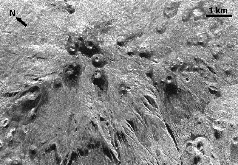
During the second SIR-C flight, some of the data was obtained
at very high resolution so that topographic mapping could be
performed via a technique called "radar interferometry"> This
image of the summit of Kohala volcano shows the advantage
of this high-resolution mode. Notice the graben that forms the
summit of the volcano, and all of the fine stream channels that
are to the bottom of this image.
|
|
|
This is a Space Shuttle radar (SIR-C) image of Mauna Kea volcano,
which is the site of all the world famous astronomical telescopes on
the Big Island. The different colors have been generated by
displaying different radar wavelengths as different colors. Red
corresponds to L-band
(23 cm) horizontally transmit and receive (HH polarization),
green is L-band horizontally transmit and vertically receive
(HV polarization), and blue is C-band (5.6 cm) horizontally
transmit and vertically receive (HV polarization). The strong color
difference between the top right and top left parts of the image are
due to variations in vegetation cover and the viewing geometry of
the radar
(the "look direction" is towards the right (east) in this image).
|
|
|
Here is another SIR-C view of the summit of Mauna Kea, obtained in
October
1994. This image has a better spatial resolution (12.5 m/pixel) than the
color image because it was obtained when the radar scientists were
performing a topographic mapping experiment. As a result of the limited
amount of data that could be recorded in this manner, it was not possible
to collect 3 wavelengths or polarizations at the same time -- which is why
we only have a black and white image. However, the improvement in
resolution is remarkable, since you can now see the road going to the
summit, and the individual telescopes!
|

|
The second SIR-C mission, which took place in October 1994, collected some fine images of Mauna Loa volcano. Here we can see the summit crater surrounded by the rough (red) a'a lava flows and the smoother (blue) pahoehoe lava flows. The town of Kona on the western side of the island is just off the left of this image. The different colors have been generated by displaying different radar wavelengths as different colors. Red corresponds to L-band (23 cm) horizontally transmit and receive (HH polarization), green is L-band horizontally transmit and vertically receive (HV polarization), and blue is C-band (5.6 cm) horizontally transmit and vertically receive (HV polarization).
|

|
This is a Space Shuttle radar (SIR-C) image of the town of Hilo on the northeast side of the Big Island. The black line close to the Bay is the Lyman Field Airport. Notice that several of the lava flows (the red and green linear features at bottom left) from Mauna Loa can be easily seen despite the fact that they are run through tropical vegetation on the lower slopes. The different colors have been generated by displaying different radar wavelengths as different colors. Red corresponds to L-band (23 cm) horizontally transmit and receive (HH polarization), green is L-band horizontally transmit and vertically receive (HV polarization), and blue is C-band (5.6 cm) horizontally transmit and vertically receive (HV polarization). |
Go directly to: | Top of Page | Big Island | All Islands |

Author: Lori Glaze
Copyright by Pete Mouginis-Mark
Curator: Lori Glaze