 Molokai From the Air

We hope you enjoy this small selection of pictures taken from the air during some of the radar and spectral measurements that were collected in 1985 and 1990. Come back soon, because we hope to have a whole new section showcasing these images in the near future!
|
Aerial location number 1: The northwest rift zone of the old West Molokai volcano has produced a peninsula called Ilio Point, which is shown here. Many large sand dunes, which can be almost 20 meters high and 0.8 km wide, cover this part of the island. An example of these dunes can be seen at Stop #2 , which is taken from Moomomi Beach. |
|
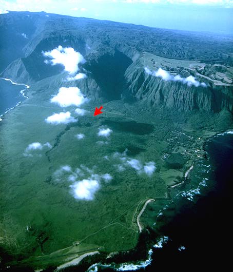
Aerial location number 2: Many tens of thousands of years ago, the north side of Molokai island fell into the ocean in what must have been a spectacular landslide! The remnants of the island on the north shore form the steep sea cliff which we can see here in the middle distance. Closer to the camera is the Kalaupapa Peninsula, which is famous for the settlement which is on the west (right-hand) side of the peninsula. This peninsular formed late in the history of Molokai, long after activity on the main shield volcano stopped, and was formed by the eruption of Kauhako Crater (arrowed). This crater is more than 135 meters deep, and extends well below sea level. For a good idea of the shape of the small lava shield that was formed in this eruption, see ground photo #3. |
|
Aerial location number 3: This is a close-up view of Kauhako Crater on the Kalaupapa Peninsula. (see Aerial Photo #2 for location). |
|
Aerial location number 4b: More cliffs along the northern shore of East Molokai. |
|
Aerial location number 7a: These are closer views of coral reefs near the Kamalo area of SE Molokai. |
|
Aerial location number 7b: More close-up views of the coral reefs near the Kamalo area of SE Molokai. |
|
Aerial location number 9: Another view of the southern side of East Molokai volcano, showing fine examples of stream valleys carved in the volcanic shield. |
You have now completed the aerial tour around Molokai. If you would like, you may begin the ground tour at the beginning, or visit a specific stop on the ground tour by returning to the Molokai Virtual Field Trip page.
![]() [Return to top of
Molokai Virtual Field Trip
]
[Return to top of
Molokai Virtual Field Trip
]
Author: Peter Mouginis-Mark
Copyright by P. Mouginis-Mark
Curator: Lori Glaze